Ranu Kumbolo, the iconic alpine lake on Mount Semeru's trekking route, remains closed due to ongoing eruption activity. Here's what to know and when to check back.
Ranu Kumbolo is closed. That is the most important thing to know about one of Indonesia's most photographed alpine lakes right now, and it has been the case since a series of eruptions on Mount Semeru forced authorities to shut down the trekking corridor in late 2021. The closure remains in effect, and there is no announced reopening date. Anyone planning a trip to East Java with Ranu Kumbolo on the itinerary needs to start with that reality.
What follows is context — what this place is, why it draws tens of thousands of trekkers in normal years, and how to monitor the situation if you're hoping to visit when access eventually resumes.
What Ranu Kumbolo Is
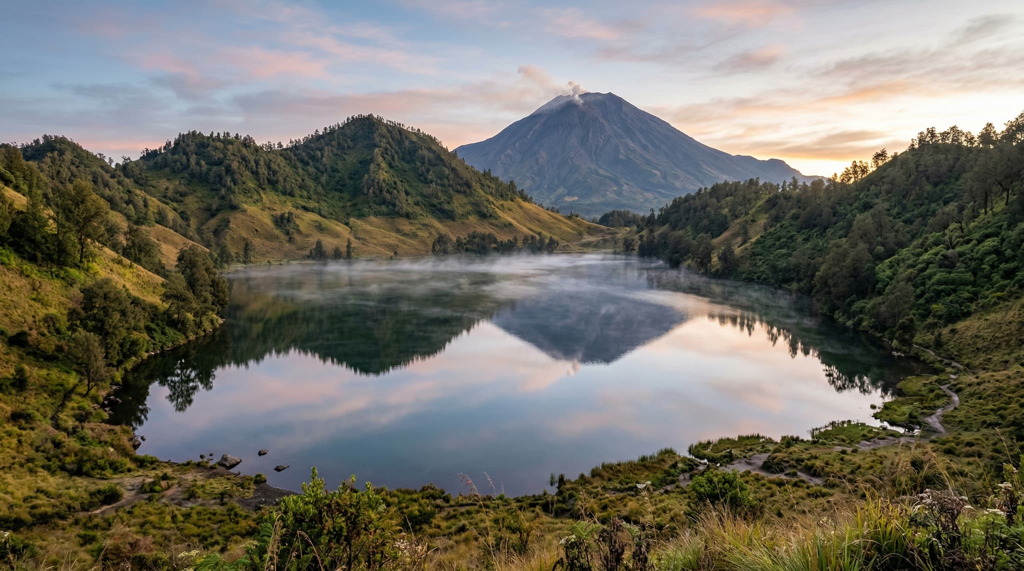
Ranu Kumbolo is a volcanic lake sitting at approximately 2,390 meters on the northern slope of Mount Semeru, Java's highest peak and one of Indonesia's most active volcanoes. The lake occupies a caldera depression surrounded by grass-covered hillsides that shift between green and gold depending on the season. It measures roughly 500 meters across — not enormous, but striking in context. At that elevation, framed by the volcanic terrain of the Tengger massif, the lake has an almost implausible stillness to it. The water is clear, cold, and fed by rainfall and seepage rather than any visible inlet stream.
The lake sits within Bromo Tengger Semeru National Park (Taman Nasional Bromo Tengger Semeru, or TNBTS), the same protected area that includes the more tourist-accessible Mount Bromo. But where Bromo draws visitors who arrive by jeep and walk twenty minutes across a sand sea, Ranu Kumbolo requires a proper trek — roughly 12 kilometers from the Ranu Pani trailhead, the gateway village at around 2,100 meters elevation.
The Trek to Ranu Kumbolo (When Open)
Starting Point
Ranu Pani village (2,100 m)
Distance
~12 km one way
Typical Duration
4-5 hours uphill
Trail Difficulty
Moderate — clear path, steady incline
Camping
Designated campsite at the lakeshore
Why Trekkers Care

For Indonesian hikers — and Ranu Kumbolo is overwhelmingly an Indonesian hiking destination — the lake functions as both a landmark and a rite of passage. It is the midpoint camp on the route to Semeru's summit (Mahameru, 3,676 meters), and for many young Indonesians, summiting Semeru is one of the defining outdoor experiences of their twenties. Ranu Kumbolo is where you sleep before the pre-dawn push to the top.
But plenty of trekkers come for the lake itself and go no further. The campsite along its shore became one of the most iconic camping spots in Southeast Asia — the kind of place that fills Instagram feeds every dry season. Sunrise over the lake, with mist lifting off the water and the surrounding hills catching the first light, is the image most associated with the place. During peak season (typically April through October, when East Java's dry weather holds), the campsite could host hundreds of tents on a single weekend.
The 2016 Indonesian film 5 CM, based on Donny Dhirgantoro's novel about five friends who trek to Semeru's summit, amplified Ranu Kumbolo's already significant cultural profile. The film turned the trek into something approaching a national bucket-list item, and visitor numbers surged in the years that followed.
The Eruption and Closure

Mount Semeru erupted violently on December 4, 2021, sending pyroclastic flows down its southeastern slopes and killing at least 51 people in downstream villages. The disaster prompted an immediate closure of the entire Semeru trekking corridor, including all access to Ranu Kumbolo.
Semeru had been active well before that — it is one of Java's most consistently erupting volcanoes, producing small ash plumes and minor eruptions regularly. But the December 2021 event was a different order of magnitude, and subsequent eruptions in 2022 and 2023 reinforced the decision to keep the trekking route closed. The volcano's alert level has remained elevated.
The closure is managed by TNBTS in coordination with PVMBG (Pusat Vulkanologi dan Mitigasi Bencana Geologi), Indonesia's volcanological authority. As of this writing, there is no published timeline for reopening. Periodic reports from PVMBG indicate continued volcanic activity — elevated seismicity, intermittent ash emissions, and occasional pyroclastic events — that make reopening the summit corridor untenable.
What This Means for Planning
If Ranu Kumbolo is on your list, the honest answer is: wait. Monitor the situation, and do not book travel to East Java specifically for this trek until the closure is officially lifted.
The sources to watch are:
Where to Check for Updates
TNBTS
Official national park social media and website for trail status
PVMBG
magma.esdm.go.id — volcanic alert levels and activity reports
BNPB
Indonesia's national disaster agency for broader safety advisories
When the trail does eventually reopen — and it likely will, given Semeru's importance to Indonesian outdoor culture and East Java's tourism economy — expect updated regulations. The pre-closure quota system will almost certainly return in some form, and advance registration through the TNBTS booking system was already mandatory before 2021. Permits were affordable (in the range of IDR 20,000–30,000 for domestic visitors, higher for international trekkers), though pricing may change.
The Broader Area

Travelers already in East Java have alternatives that remain accessible. Mount Bromo, in the western section of the same national park, operates independently of the Semeru closure and continues to receive visitors normally. The Ijen crater and its famous blue flames, located further east in Banyuwangi Regency, is another major volcanic trekking destination unaffected by Semeru's status.

Neither of these replicates the Ranu Kumbolo experience — the multi-day trek, the alpine camping, the particular quality of that lake at that elevation. But East Java's volcanic landscape is deep enough that a trip built around Bromo and Ijen remains one of the strongest outdoor itineraries on Java.
A Note on This Article
This piece is research-based. The Semeru trekking corridor has been closed throughout the period of reporting, and the practical details included here — trail distances, elevation, permit structures — reflect conditions as they existed before the closure. These details will need verification against current regulations when the trail reopens. The volcanic status information reflects the most recent available reporting from PVMBG and Indonesian disaster management authorities, but volcanic conditions change. Always check primary sources before making travel decisions involving active volcanoes.