Mount Rinjani: Lombok's Sacred Volcano and One of Indonesia's Greatest Treks
Mount Rinjani rises 3,726 meters above Lombok, sheltering a sacred crater lake and one of Indonesia's most rewarding multi-day volcano treks.
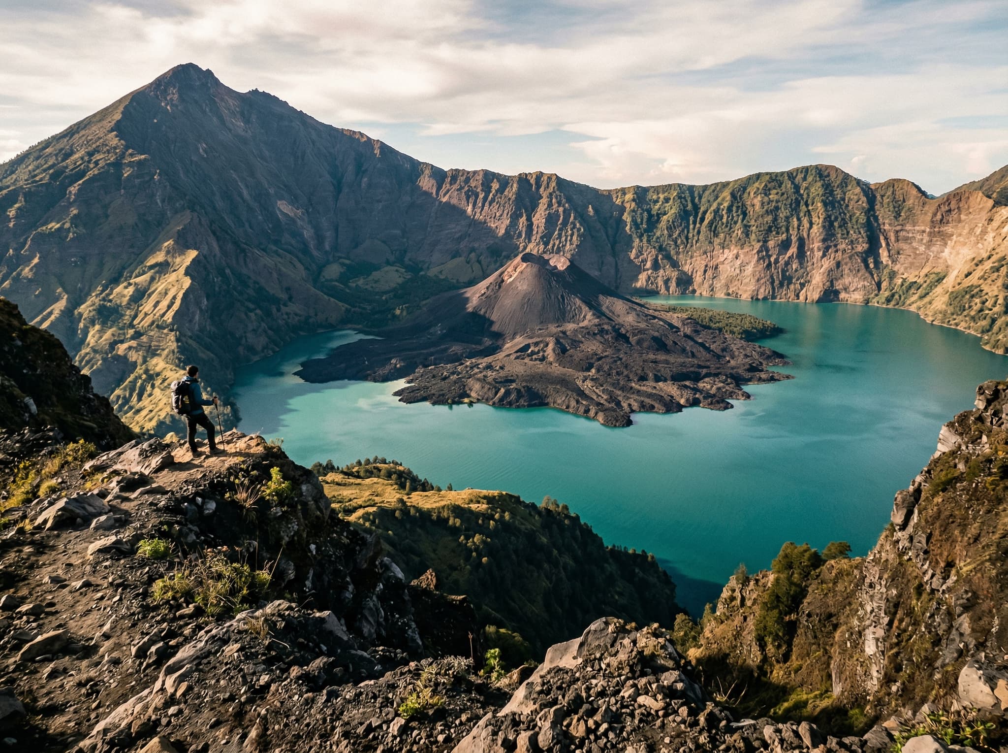
At 3,726 meters, Mount Rinjani is Indonesia's second-tallest volcano and the highest point on Lombok. But the numbers don't capture it. What makes Rinjani extraordinary is the landscape inside — a massive caldera holding Segara Anak, a crescent-shaped crater lake 600 meters below the rim, its turquoise surface broken by the cone of Barujari, a smaller active volcano that last erupted in 2016. It's a volcano inside a volcano beside a sacred lake, and it looks like something a fantasy novelist would reject for being too much.
For the Sasak people — Lombok's indigenous ethnic majority — Rinjani is not scenery. It's the spiritual axis of the island.
A Mountain Between Two Faiths

Rinjani sits at the intersection of two living spiritual traditions. The Sasak, who are predominantly Muslim, regard the mountain as a place of ancestral power. The lake's name, Segara Anak, translates to "Child of the Sea," reflecting a belief that the lake is connected to the ocean through subterranean channels. Each year during the Mulang Pekelem ceremony, Sasak communities and Balinese Hindu priests both make offerings at Segara Anak — gold, cloth, livestock — returning gifts to the lake to maintain balance between the human and spiritual worlds.
For Lombok's Balinese Hindu minority, Rinjani is the seat of the gods, a counterpart to Bali's Mount Agung. The full moon ceremony at the lake draws pilgrims who bathe in the hot springs near the shore, believing the volcanic water has purifying properties.
This dual significance — Islamic Sasak and Balinese Hindu, running in parallel on the same mountain — is unusual in Indonesia and largely unknown outside of it. The mountain is not a cultural artifact. It's an active sacred site where ceremonies have continued without interruption.
What the Mountain Feels Like

The two main trailheads — Sembalun on the east and Senaru on the north — offer fundamentally different approaches to the same mountain.
Sembalun starts in open savanna that looks more like East Africa than Southeast Asia: rolling grassland, wide sky, the volcano rising ahead with deceptive gentleness. This is the more direct route to the summit and the one most trekkers use for a sunrise push. The final ascent is a steep scramble up loose volcanic scree in the dark, headlamp-lit and wind-battered, the kind of climb where you measure progress in meters rather than minutes.
Senaru begins in dense tropical forest — mossy, humid, the canopy filtering light into green. The trail climbs through shifting vegetation zones before breaking onto the crater rim, where the landscape opens without warning. One moment you're in the trees. The next, the entire caldera is below you.

The descent to Segara Anak is where the mountain changes character entirely. The rim is exposed, wind-scoured, volcanic in the bleak and beautiful sense. The lakeshore is sheltered, almost gentle — flat ground, hot springs steaming near the water's edge, the inner cone of Barujari reflected in the surface. The contrast rearranges your sense of scale. You've spent hours climbing to the rim. Now you're standing at the bottom of something far larger than the summit suggested.
Trek Routes at a Glance
Sembalun Start
Open savanna, direct summit access, steeper ascent
Senaru Start
Forest trail, crater rim views, longer approach
Most Popular Route
Sembalun up, Senaru down (or reverse) — 3 days / 2 nights
Summit Elevation
3,726 m (12,224 ft)
Practical Realities

All treks require a licensed guide and must be booked through a registered trekking operator — independent hiking is not permitted within Rinjani National Park. Two- to four-day packages are standard, with the three-day Sembalun-to-Senaru traverse being the most common. Packages typically run from USD $150–350 per person depending on group size, duration, and inclusions. Porters carry the camping equipment and cook meals; you carry a daypack.
The park closes entirely from December through March due to heavy rain and landslide risk. April and May can still be wet. The driest and most reliable months are June through September, which are also the busiest.
Fitness matters more than experience. You don't need technical climbing skills, but the summit push involves 1,000 meters of elevation gain on loose volcanic gravel, often starting at 2 or 3 a.m. Altitude can affect anyone above 3,000 meters. The descent to the crater lake is steep and slippery. This is a serious mountain trek, not a day hike with a view.
Why Rinjani
Indonesia has 127 active volcanoes. Several are more accessible. A few are taller. But Rinjani offers something rare — a landscape so layered it keeps revealing itself. The savanna, the forest, the exposed rim, the hidden lake, the volcano within the volcano. And underneath all of it, a mountain that two faiths have considered sacred for centuries, where offerings still go into the water and pilgrims still climb to pray.
It's not the easiest trek in Southeast Asia. It's one of the most rewarding.